


JUNE 30, 2026
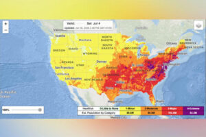
A NWS graphic depicts areas facing most impactful heat on July 4.
Meteorologists are warning that millions of people could face dangerous heat this week as a heat dome brings several days of extreme temperatures, high humidity, and intense sunshine around the Fourth of July.
The worst of the heat is expected to peak from Tuesday through Thursday across the Midwest and Mississippi Valley before spreading into the Ohio Valley and East Coast later in the week and into the weekend, according to the National Weather Service (NWS).
“We have observed over the last 10 years or so that heat domes are becoming more intense, often breaking records in recent years,” Porter said. “There is growing research that points toward increased persistence of blocking patterns associated with heat domes in a warming atmosphere, which allows a hot pattern to linger for longer periods.”
The NWS said widespread major to extreme HeatRisk is likely across much of the region east of the Mississippi Valley. High temperatures in the 90s to low 100s, combined with high humidity, are expected to push heat index values to between 100 and 110 degrees, with some areas reaching as high as 115.
HeatRisk: What Level 4 ‘Extreme’ Actually Means
HeatRisk is a color-coded system that uses detailed weather, climate, and CDC health data to indicate potentially dangerous heat levels. The heat index reflects what temperatures actually feel like when humidity is factored in.
The system runs from Level 0 to Level 4, with the highest category signaling rare and prolonged extreme heat. According to the NWS Weather Prediction Center, Level 4 “Extreme” heat risk indicates conditions that can affect anyone without adequate cooling or hydration, while also straining infrastructure and healthcare systems.
“These levels of heat mean health impacts become more likely in general, and may occur in anyone without adequate hydration or cooling,” the NWS said, adding that the extreme heat may persist into next week across the central and eastern U.S., with some relief possible by July 7.
That level is forecast across wide areas—including parts of the Midwest, Ohio Valley and Northeast—from Thursday through Saturday, covering states such as Michigan, Illinois, Pennsylvania, New York, and Virginia, among others.
An NWS map indicated that areas including parts of Michigan, Wisconsin, Illinois, Indiana, Ohio, Iowa, Missouri, Tennessee, Kentucky, West Virginia, North Carolina, Virginia, Pennsylvania, and New York are expected to face Level 4 (Extreme) HeatRisk from Thursday through Saturday, July 4.
The NWS also said that dozens of record highs are expected to be broken across much of the Northeast later in the week. A separate graphic shared by the agency highlighted locations across the following states that could see records broken on Thursday, Friday, and Saturday, including:
- Maine
- Vermont
- New Hampshire
- Massachusetts
- Connecticut
- New York
- New Jersey
- Pennsylvania
- Ohio
- Michigan
- West Virginia
- Kentucky
- Rhode Island
- Maryland
- Virginia
- North Carolina
- Tennessee
Areas Facing Most Impactful Heat on July 4
NWS data for July 4 highlights the most impactful heat (purple) concentrated across parts of the Mid‑Atlantic and central Appalachians, surrounded by widespread major heat risk (red) across much of the eastern half of the country.
Heat Dome vs Heat Wave: What’s the Difference?
“The persistence and long-lasting nature in a particular area is the key difference between the impacts of a heat dome and a typical stretch of hot weather which might last a short duration,” said AccuWeather chief meteorologist Jonathan Porter in an email from the outlet sent to Newsweek on Monday. “Heat domes can prevent clouds from forming, resulting in abundant sunshine that boosts temperatures, potentially toward record levels.”
As explained by AccuWeather, the terms “heat dome” and “heat wave” are often mentioned together, but they refer to different phenomena.
A heat dome is a broad weather pattern that traps hot air over a region, sometimes for a week or longer.
In contrast, a heat wave describes a shorter-term stretch of unusually high temperatures—typically lasting three or more consecutive days—when conditions exceed a particular area’s normal heat thresholds.
As explained by AccuWeather, a heat dome functions like a lid over the atmosphere, keeping hot air confined to the same area for a prolonged stretch.
Under these conditions, cloud formation, rainfall, and thunderstorms are limited, while steady sunshine allows temperatures to rise. At the same time, the ground loses moisture more rapidly, heightening the risk of drought, and lighter winds make it easier for pollutants to accumulate—reducing air quality, especially in densely populated urban areas, per AccuWeather.
It added that heat domes have grown stronger in recent years, with many leading to record-setting temperatures.
Extreme Heat Safety Tips
The NWS urges people to take precautions during prolonged heat, warning that extreme temperatures can strain the body and lead to serious illness.
Who is most at risk:
- Young children
- Older adults
- Pregnant women
- People with underlying health conditions
Officials’ recommendations:
- Stay hydrated throughout the day
- Limit time outdoors during the hottest parts of the day
- Wear lightweight, loose-fitting clothing
- Take frequent breaks in shaded or air-conditioned areas
- Check on vulnerable neighbors, relatives, and friends
- Never leave children or pets unattended in vehicles, where temperatures can rise rapidly
Heat-related illness—Warning signs to watch for:
- Dizziness
- Heavy sweating
- Nausea
- Confusion
- Weakness
Anyone experiencing severe symptoms — particularly signs of heat exhaustion or heat stroke — should seek immediate medical attention.
Courtesy: Newsweek


