


JANUARY 3, 2024
A major winter storm packing travel-snarling snow and dangerous ice is on track to arrive in the Northeast this weekend, a storm that AccuWeather meteorologists say will deliver the first big snowfall along the Interstate 95 corridor in nearly two years.
The cross-country storm will first push across the Southwest into Thursday before swinging eastward, where it will deliver heavy rain and thunderstorms to the Gulf Coast states before evolving into the year’s first snowstorm along the East Coast.
From late Thursday night to Friday night, a swath of drenching rainfall and locally gusty thunderstorms will begin to impact areas of the Gulf Coast. The persistent rainfall could bring drought relief for some, especially for parts of Louisiana and Mississippi where levels of extreme to exceptional drought have gripped the region, according to the U.S. Drought Monitor.
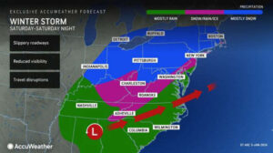
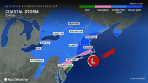
As the storm advances northeastward to the mid-Atlantic coast Saturday into Sunday, it is expected to strengthen as it dumps snow and ice across the mid-Atlantic and southern New England. Forecasters caution that heavier bands of snow can develop from West Virginia and northwestern Virginia to the Hudson Valley during this time.
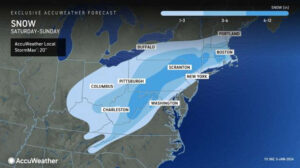
Travel conditions can rapidly deteriorate throughout Saturday and Saturday night as snow and ice spread across the region. From Saturday to Sunday, a swath of 3 to 6 inches of snow is projected to fall from the Smoky Mountains through much of northern and eastern West Virginia on northeastward to interior southern New England.
Higher snowfall totals between 6 to 12 inches can be collected from the higher terrain in eastern West Virginia, central Pennsylvania on northeastward to central Massachusetts, with the AccuWeather Local StormMax™ of 20 inches.
“The most significant wintry effects from the storm will be limited to about 12 hours or so from late Saturday into Sunday evening,” explained AccuWeather Senior Meteorologist Courtney Travis.
Motorists are urged to check their local forecast and stay aware of changing weather conditions before taking to the roads, especially any college students returning to campus since winter break comes to an end this week for some universities.
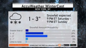
After a relatively mild December for parts of the Northeast, this weekend’s storm may be a sharp snap back to reality for some, as the heart of winter is quickly approaching. This weekend, millions across the Northeast may experience their first winter storm featuring snowfall amounts greater than 1 inch since early 2022.
“Any accumulating snow can result in significant travel slowdowns, but this storm may have greater impact than others of similar magnitude because it has been such a long time since more than 1 inch of snow has accumulated in these areas – it can take people a bit of time to once again get used to driving in and otherwise dealing with the snow,” explained AccuWeather Chief Meteorologist Jon Porter. “This is typically experienced during the first snowstorm of a season, like this one, but is amplified since it’s the first storm in several years,”
“A few inches of snow or more can occur along the I-95 corridor from Washington, D.C., to Baltimore, Philadelphia, New York City and Boston, which would be the most snow some of these cities have seen since early 2022 thanks to the multiyear drought of major snowstorms in these areas,” added Porter.
The last time a single storm delivered more than an inch of snow in New York City was on Feb. 13, 2022, while the last time there was a snowstorm that brought at least an inch of snow to Philadelphia was on Jan. 28-29, 2022.
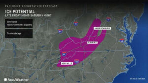
As cold air is pulled southward, a mixture of snow, sleet and freezing rain can spread over parts of far eastern Tennessee and western North Carolina through eastern West Virginia and western Virginia, but the ice threat is mainly expected to be elevational dependent. Locations surrounding the Smoky Mountains to the Blue Ridge Mountains could face the greatest risk for dangerous ice buildup.
While some elevations could receive a mixture of snow and sleet, leaving untreated sidewalks and roadways slippery, others could have mainly freezing rain. The accumulation of ice poses additional risks, including the potential for tree branches to snap and weigh down power lines, leading to power outages.
“Travelers are urged to exercise extreme caution as seemingly wet roads may be coated with a hazardous layer of ice,” noted AccuWeather Meteorologist Elizabeth Danco.
Being prepared with extra batteries, fully-charged cell phones and a generator, if available, will come in handy in the case of localized or widespread power outages.
Residents across portions of the Tennessee and Ohio valleys through New England will want to dust off their snow shovels and snow blowers and ensure their vehicle tires have a healthy amount of tread on them in advance of the storm’s arrival. Additional preparations, such as getting out sidewalk salt and cinders and packing an emergency kit in their car that contains an extra hat, gloves or scarf, may be helpful.
As the storm shifts northward along the New England coast by Sunday, the steadiest snow is expected to focus on areas of northern Connecticut, Massachusetts, southern New Hampshire and parts of far southern Maine. Forecasters say that a separate storm tracking north of the Great Lakes and across southern Canada can also factor into how long snow showers persist across the interior Northeast.
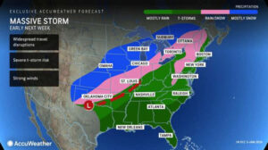
AccuWeather meteorologists warn that another widespread and impactful storm may be on the way next week following this weekend’s storm. A feature expected to shift inland from the West Coast later this weekend and organize over the Central states by Monday can become the next major winter storm.
A corridor of snow, sleet and even a zone featuring blizzard conditions can develop over the center of the country early next week. On the storm’s southern flank, warm, moist air can clash with the chilly air pushing southward from the Midwest to spark rounds of heavy rain and gusty thunderstorms along the Gulf Coast. Forecasters warn that some storms can even turn severe with the risk of damaging winds and isolated tornadoes.
Courtesy: AccuWeather


