


FEBRUARY 4, 2023

Minus one-oh-eight: That’s how cold it felt on top of New Hampshire’s Mount Washington early Saturday, and it wasn’t a whole lot warmer anywhere else in New England or in eastern Canada as an air mass that normally squats over the Arctic surged into the temperate latitudes and set wind chill and absolute-temperature records across the region.
The Mount Washington Observatory’s wind chill calculation of minus-109 Fahrenheit set an all-time record for the United States. (The National Weather Service, the official keeper of records, said it was a smidgen warmer at minus-108.) And temperatures across the Northeast reached lows not seen in decades, in many places 30 degrees lower than the seasonal average, combining with gusty winds to create dangerous conditions for anyone venturing outside.
Thousands of people reported power loss across the region, but the impacts from the Arctic pulse appear to have been minimal, with no immediate reports of cold-related fatalities.
The National Weather Service office serving the Boston region described the cold as “a historic Arctic outbreak for the modern era.” To drive that point home, the Weather Service declared “this is about as cold as it will ever get.”
The temperatures were so extreme in Maine that residents reported “frost quakes,” or cryoseisms. The earthquake-like tremors are caused by rapidly plummeting temperatures, which cause water trapped in cracks in the ground to expand.
Weirdly, this historic Arctic weather is kind of like a cold snap on steroids, coming and going with startling speed. Temperatures in parts of New England could reach 50 degrees Sunday.
“You’re talking about a feels-like temperature swing of 60 or 70 degrees in 24 hours,” said Robert Megnia, a meteorologist with the National Weather Service in Boston. “I don’t know that I’ve witnessed a swing of that magnitude before.”
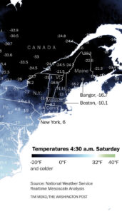
In Boston, the morning low fell to minus-10 degrees at 5:15 a.m., the coldest reading observed in the city since Jan. 15, 1957, when Boston hit minus-12. The episode resembled the brutal Arctic blast on Valentine’s Day 2016, when Logan Airport dropped to minus-9 degrees.
Coupled with winds gusting near 40 mph, Boston witnessed its lowest wind chill ever recorded at minus-39 degrees. Records date back to 1944. Wind chill is an index that attempts to quantify the combined impact of cold and wind on the human body, since strong winds blow away one’s body heat.
Portland, Maine, recorded its all-time lowest wind chill at minus-45 degrees. A weather balloon launched by the National Weather Service in Gray, Maine, reported the all-time lowest 850-millibar (an air pressure level corresponding to approximately 5,000 feet in altitude) temperature ever observed by that office at minus-35.5 degrees.
Farther north in Maine, Frenchville Airport in Aroostook County recorded a wind chill to minus-61 degrees, while Cadillac Mountain in Hancock County had a minus-62 degree wind chill. Even Bar Harbor, on the coast, logged a wind chill of minus-48. Greenville in Piscataquis County faced a wind chill of minus-58.
Just across the Maine border in Canada, the province of New Brunswick recorded winds of over 35 mph Saturday afternoon and a wind chill of minus-35. The cold first hit the country on Friday in Ontario, which saw wind chills as cold as minus-50 in some areas and minus-24 at Toronto Pearson International Airport.
On Saturday in the country’s Northwest Territories, the wind chill was minus-58, though temperatures eased later in the day, according to Environment Canada, the country’s official weather service. In Newfoundland and Labrador, in the northeast, winds were as strong as 70 mph in exposed areas near the coast as snow fell across the province. In Nunavut, the northernmost territory, wind chills were as low as minus-67.
Beyond Mount Washington’s mind-boggling wind chill of minus-108, the actual air temperature scored at the summit was minus-46.2 at minimum — a new February record for New Hampshire. That coincided with wind gusts topping 110 mph. The Weather Service office serving the area tweeted that the wind chill was so low that its software for logging such data “refuses to include it!”
Even more impressive was the fact that Mount Washington, by some accounts, protruded into the stratosphere — the second layer of Earth’s atmosphere. Ordinarily located more than 20,000 feet above the ground even in the dead of winter, the stratosphere “folded” down in a series of bunched-up pinches. One of them helped tug a filament of the stratosphere low enough that the summit of the 6,288-foot mountain poked into it. That said, the summit did not record a noticeably dramatic uptick in ozone, which would be the case if the stratosphere fully descended to that level.
There were also instances of trees exploding — the result of quickly expanding water stored in sap. Some in northern New England recalled hearing sounds analogous to gunshots.
A TikTok user commented, “They’re popping all night here [in] Massena, New York.”
“I’ve been hearing gunshot sounds for the last 8 hours and kept walking around the house trying to figure out what it was!” tweeted Sofia Fojo. “I’m in Vermont and have a ton of maple trees around.”
In Upstate New York, the actual air temperature — not factoring in wind — fell as low as minus-38; wind chills there dipped to minus-50.
In Vermont, Mount Mansfield logged a low temperature of minus-35. Burlington was cold — but not record cold. The city started the morning around minus-15 degrees, which paled in comparison to the minus-26 degree morning low set on Feb. 4, 1963.
Worcester, Mass., made it down to minus-13 degrees, compared to the daily record of minus-4 last set in 1934.
There were even reports of winter waterspouts — akin to devilish vortexes of stream — on Lake Champlain and over the open Atlantic. The frigid air blowing over comparatively mild waters caused a rare type of fog known as Arctic sea smoke to form, while shallow updrafts stretched eddies within the fog to the puffy cloud bases above.
The fleeting, but intense, Arctic cold shot is the result of dual pressure systems parked to the north. A low is pushing east through Ontario en route to the Canadian Maritimes, while Arctic high pressure hovers over the northern Plains. Highs spin clockwise in the Northern Hemisphere, while lows spin counterclockwise; like meshing gears, the two oppositely spinning air masses conspire to entrain a strip of polar air from near the Hudson Bay and convey it southeast.
At higher altitudes, a lobe of the polar vortex — a pool of frigid air — dived from near Hudson Bay, Canada, directly over Maine.
Courtesy/Source: Washington Post


