


DECEMBER 18, 2022
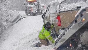
Drivers struggled with snow-covered roads in Jamaica, Vt., on Friday. Forecasters warn that another storm could make for hazardous travel leading up to Christmas. – Kristopher Radder/The Brattleboro Reformer, via AP
A winter storm is expected to develop and move across parts of the Central Appalachians, eastern Great Lakes, Mid-Atlantic and Northeast, bringing a mix of strong winds, rain and snow that could make travel dangerous leading up to the holiday weekend, the National Weather Service said on Sunday.
A bitterly cold Christmas also is in store for vast sections of the Central and Eastern United States as a blast of arctic air is expected to sweep in, sending temperatures plunging far below their late December averages, forecasters said.
“The tandem of bitterly cold temperatures and an intensifying storm system over the Rockies and Central Plains by midweek, will mean treacherous travel for many locations along and east of the Rockies,” the Weather Service said, adding that anyone in those regions should closely monitor the forecast.
In the Northern Plains and Upper Midwest, temperatures could dip into the negative teens by Christmas Eve and the following days, according to the service. It said subzero temperatures could reach as far south as the Central Plains, while the stretch from the Northeast to the Ohio Valley and up to the Great Lakes can expect temperatures in the single digits. Below-freezing temperatures are forecast even for parts of southern Texas, the Gulf Coast and Florida over the weekend and into the following week, the service said.
“For some folks, it could be one of the coldest Christmases in a while,” said Zackary Taylor, a senior meteorologist with the Weather Prediction Center.
“The cold air spilling southward is certainly some of the coldest air we’ve seen so far this winter and there is the potential there for some record low temperatures,” he said, adding that temperatures across much of the eastern two-thirds of the country were expected to drop as much as 30 degrees below normal for this time of year.
The cold air mass is expected to begin its surge southward by the middle of the week, sweeping from the Northern Rocky Mountains toward the eastern part of the country.
Along the leading edge of the cold air mass, a winter storm will develop across parts of the Central Appalachians, eastern Great Lakes, Mid-Atlantic and Northeast, forecasters said. A mix of strong winds, rain and snow is likely leading up to the holiday weekend, Mr. Taylor said.
“The system is going to be pretty strong, and pretty dynamic, such that it’s going to create some hazardous weather conditions, and probably travel disruptions,” he said.
Cities on the East Coast, including New York City and Washington, are unlikely to have a white Christmas as the storm will probably pass on Thursday and Friday as a “rain event” before temperatures plummet. New York is forecast to reach a high near 28 degrees on Christmas Day.
The best chance of heavy snow, Mr. Taylor said, was over the Ohio Valley into the Great Lakes and the interior Northeast.
Parts of the United States will experience anomalously cold conditions for this time of year, forecasters said. Houston is forecast to reach a high near 29 degrees on Friday, while New Orleans is expected to reach a high near 34.
“The cold will probably impact more people but the snow and wind is going to be pretty significant where it does occur,” said Marc Chenard, a meteorologist with the Weather Prediction Center.
He added that clearing the roads of snow under such conditions could prove challenging. “It’s going to be so cold, it’s not going to melt,” he said.
Courtesy/Source: NY Times


