OCTOBER 8, 2022

Tropical Storm Julia
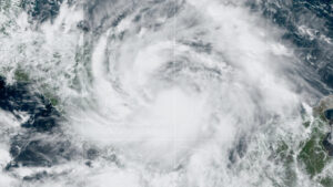
Tropical Storm Julia was bearing down on several Colombian islands on Saturday afternoon and began heading quickly toward Nicaragua, forecasters said.
The storm, expected to become a hurricane late on Saturday, was about 55 miles south of Isla de San Andres, a Colombian island, as of 5 p.m. on Saturday, with maximum sustained winds of 70 miles per hour, the National Hurricane Center said in an advisory.
The storm was about 175 miles east-northeast of Bluefields, a municipality on the east coast of Nicaragua.
A hurricane warning from the Colombian government for the islands of Providencia, San Andrés and Santa Catalina was in effect, as well as one for parts of Nicaragua. Tropical storm warnings were in effect for the entire Pacific Coast of Nicaragua, El Salvador and Honduras. A tropical storm watch was in effect for the entire coast of El Salvador. The warnings refer to storm conditions that are expected within 36 to 48 hours.
Forecasters warned of life-threatening flash floods and mudslides from heavy rains over Central America through the weekend.
Julia has been strengthening as it churns westward across the southwestern Caribbean Sea. It is forecast to pass near or over the San Andrés and Providencia islands by Saturday evening as a hurricane, the Hurricane Center said.
From there, it will most likely reach the coast of Nicaragua on Sunday morning and travel across Central America more slowly, the center said.
Heavy rainfall could set off flash flooding and mudslides in parts of Central America, which could get four to eight inches of rain, and up to 15 inches in isolated areas, the Hurricane Center said.
A storm surge could raise water levels four to six feet above normal tide along the coast of Nicaragua, with large and damaging waves, forecasters said.
Swells generated by the storm are already affecting Jamaica and were likely to cause life-threatening surf and rip current conditions.
Providencia, the Colombian island under a hurricane warning, was decimated by Hurricane Iota in 2020, according to the United Nations.
“Although the loss of human life was minimal, the impact on the island’s precious ecosystems deeply changed the perspective of its inhabitants,” the United Nations said. “Two years later, they’re still working to get back their environmental treasures and preparing for the next challenge climate change might bring.”
The Colombian government was watching the progression of the storm to plan how it could support the Caribbean region.
“We are on maximum alert,” Gustavo Petro, the president of Colombia, said on Twitter on Saturday.
He directed hotels to open space for people who needed to seek refuge in the areas affected.
The Ministry of Public Works in El Salvador had machinery and technicians ready on Saturday morning to attend to storm-related emergencies.
“We are all organized to execute work that protects lives,” the department said on Twitter.
Julia formed 10 days after Hurricane Ian made landfall in Florida. Ian barreled across the state as a powerful Category 4 storm, destroying neighborhoods and infrastructure, unleashing floods, wiping out power and killing at least 120 people, according to state and local officials.
Ian, which later regained hurricane strength before making landfall in South Carolina, followed a relatively quiet start to the Atlantic hurricane season, which runs from June through November. There were only three named storms before Sept. 1 and none in August, the first time that has happened since 1997.
Storm activity picked up in early September with Danielle and Earl, which formed within a day of each other, and Ian, which formed on Sept. 26.
In early August, scientists at the National Oceanic and Atmospheric Administration issued an updated forecast for the rest of the season, which still called for an above-normal level of activity.
In it, they predicted that the season — which runs through Nov. 30 — could see 14 to 20 named storms, with six to 10 turning into hurricanes that sustain winds of at least 74 miles per hour. Three to five of those could strengthen into what NOAA calls major hurricanes — Category 3 or stronger — with winds of at least 111 m.p.h.
Last year, there were 21 named storms, after a record 30 in 2020. For the past two years, meteorologists have exhausted the list of names used to identify storms during the Atlantic hurricane season, an occurrence that has happened only one other time, in 2005.
The links between hurricanes and climate change have become clearer with each passing year. Data shows that hurricanes have become stronger worldwide during the past four decades.
A warming planet can expect stronger hurricanes over time, and a higher incidence of the most powerful storms — though the overall number of storms could drop, because factors like stronger wind shear could keep weaker storms from forming.
Hurricanes are also becoming wetter because of more water vapor in the warmer atmosphere; scientists have suggested storms like Hurricane Harvey in 2017 produced far more rain than they would have without the human effects on climate. Also, rising sea levels are contributing to higher storm surge — the most destructive element of tropical cyclones.
Source /Courtesy: NY Times


