JUNE 9, 2022
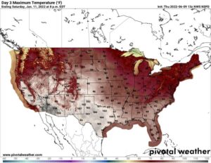
Temperatures are soaring as we head into the weekend beneath an intense and sprawling heat dome that will bring triple-digit heat to 45 million Americans in the coming week. Heat advisories and excessive heat watches and warnings blanket the map in the Desert Southwest and California, with the heat set to expand into the central United States this weekend.
By early next week, the stifling heat dome will shift to the eastern Lower 48, baking the Ohio Valley, Midwest, Southeast and Mid-Atlantic. Highs could run 10 to 15 degrees above normal, with readings peaking in the upper 90s and heat indexes topping 100.
Records could be in jeopardy in many major cities, with conditions that could prove downright dangerous for older adults, the homeless and other vulnerable populations.
The National Weather Service has issued excessive heat warnings or heat advisories for more than 30 million residents from the Desert Southwest through California’s Central Valley into the weekend.
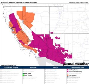
Heat alerts in effect for the Desert Southwest and California. (Pivotal Weather)
Highs in the Desert Southwest
Phoenix and Las Vegas are under excessive heat warnings through Sunday, with temperatures expected to challenge records.
“In general, we typically see the first excessive heat warning in early to mid-June, so that in and of itself isn’t incredibly abnormal, but temperatures will be approaching records,” said Jenn Varian, a meteorologist at the National Weather Service office in Las Vegas.
Record highs are forecast for Thursday and Friday in Vegas — the number to beat Thursday is 108 degrees, and a high of 109 is expected. That edges out the record set in 1996. Saturday’s projected high of 109 degrees would tie a record. The average high in Las Vegas this time of year is about 100 degrees.
“The excessive heat is here. No changes in forecast thinking,” the Weather Service office in Las Vegas wrote in its online forecast discussion. “Temperatures will remain elevated to dangerous levels.”
The heat that is affecting Las Vegas covers most of the Southwest, encompassing southern and western Arizona; most of Southern California, including the Inland Empire and deserts; and California’s heavily populated San Joaquin Valley.
Phoenix, a city of nearly 1.7 million, is forecast to hit 110 degrees on Thursday, 113 on Friday, 114 on Saturday and 113 degrees on Sunday. That should break records Thursday and Saturday and tie one Friday. It hit 110 degrees for the first time this year on Wednesday.
“High to Very High Heat Risk will be prevalent across the area through Sunday,” wrote the Weather Service in Phoenix, where an excessive heat warning is in effect through Sunday.
The Arizona Department of Environmental Quality also issued an air-quality alert, which signifies that ground-level ozone might reach dangerous levels. Near-surface ozone production is catalyzed by excessive heat and can cause breathing difficulties. The agency is urging those who use gasoline-powered equipment to hold off until late in the day.
Dangerous overnight lows
In Las Vegas and Phoenix, along with scores of other communities across the Southwest, the biggest concern isn’t daytime highs topping triple digits — it’s the exceptionally warm nighttime lows, which may not dip below the lower 80s in many locales.
“Overnight lows are the worst part of it in general,” Varian said. “If we just have highs approaching records and it cools off at night, we probably wouldn’t issue an excessive heat warning. But for people who are homeless, maybe don’t have housing, or who are trying to save a dime with air conditioning, their bodies can’t cool down at night. That’s when the impacts start.”
Maricopa County has opened dozens of cooling shelters across the Phoenix metro area, though the vast majority are open only during the daytime. A website shared by the county allows residents to search for the nearest location using their address.
In Las Vegas, the Salvation Army received funds from Clark County to reopen the day cooling shelter that had been shuttered in 2021 because of the coronavirus pandemic. A couple of other cooling shelters also were opening.
California
Excessive heat warnings are in effect through this evening for northern parts of the Central Valley, where readings in the valleys and foothills should range between 100 and 107 degrees Thursday. It’s likely that the alerts will be extended or reissued in the coming days.
“In addition to hot temperatures during the daytime, there will be little overnight relief from the heat,” the Weather Service in Hanford, Calif., warned.
Sacramento is expected to hit 101 degrees on Thursday afternoon, 105 on Friday and 102 on Saturday before returning to the upper 80s by Sunday. That could tie a record Thursday.
Heat advisories span the remainder of the Central Valley southward to where the excessive heat warning begins in Southern California, but also reach west toward the Bay Area. San Francisco downtown isn’t under any type of alert, but the high of 81 degrees expected on Friday is about nine degrees above average.
In Death Valley, the high should reach 120 degrees on Friday and 121 on Saturday — challenging daily records, with overnight lows at the Furnace Creek Visitor Center in the lower 90s. Nearby Needles should sit between 113 and 117 degrees, just a hair shy of records.
Texas and the central U.S.
Tens of millions in the Lone Star State are set to deal with toasty temperatures, too. Unlike in counterparts to the west, however, the heat that will grip Southeast Texas, including Houston and Galveston and the Interstate 10 corridor, isn’t a dry heat.
“The combination of near record high temperatures and high dew points will produce increasingly dangerous heat index values between 100 and 106 degrees today,” the Weather Service in Houston wrote in a special weather statement. The office is projecting heat indexes above 108 between Friday and Sunday, which may lead it to issue a heat advisory.
“Heat-related illnesses and deaths are preventable, and all heat safety precautions should be taken even if there is no Heat Advisory in effect!” it wrote.
Houston could nick 100 degrees any day through Sunday before simmering back into the mid-90s.
“Yes, Houston is hot in the summer, but typically not this hot in June,” headlined an article for SpaceCityWeather.com, a website for Houston weather.
Farther north, Dallas should sit around 102 degrees on Thursday and Friday before nabbing a 105 on Saturday and 103 on Sunday. With the heat dome lingering overhead, it’s probable the Metroplex will remain elevated over 100 into the middle of next week.
Austin will be between 100 and 105 each day, as will San Antonio, and no immediate relief is in sight.
Heat to swell east
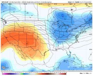
The American GFS model simulates the heat dome shifting east. (WeatherBell)
The heat is all thanks to a dome of high pressure, which is bringing clear skies and hot, dry, sinking air. The jet stream is diverting north of the high, carrying all inclement weather and storminess with it. That allows for copious sunshine, making it possible for sunlight to pour down and heat the ground unimpeded.
That heat dome will be centered over the Four Corners region on Saturday but should translate east over the Plains on Sunday and reach the eastern United States by Tuesday. Thereafter it could linger, bringing widespread highs 10 to 15 degrees above normal.
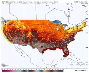
The heat shifts east into the upcoming week. Boxed numbers are predicted record highs from the National Weather Service. (WeatherBell)
It is likely to usher in what could be the first major East Coast heat wave of the season.
Human-caused climate change is supercharging heat waves like this one, making them more intense and long-lived.

