February 23, 2018
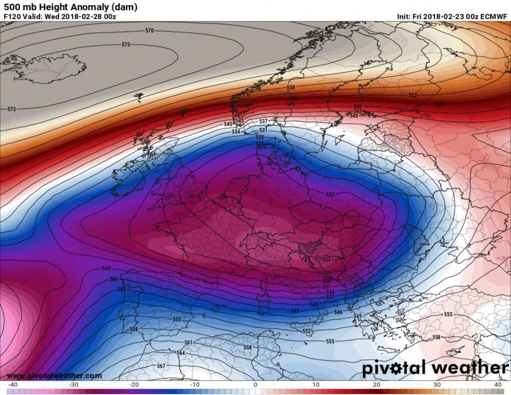
European model showing a massive pool of cold air over Europe for Tuesday night. (Pivotalweather.com)
Computer model forecasts are advertising a bout of bitter cold to sweep over Europe over the next several days, very possibly the most extreme of the winter and perhaps in several years.
February 23, 2018

European model showing a massive pool of cold air over Europe for Tuesday night. (Pivotalweather.com)
Computer model forecasts are advertising a bout of bitter cold to sweep over Europe over the next several days, very possibly the most extreme of the winter and perhaps in several years.
“The well anticipated most widespread #cold temperatures across northern Eurasia since #winter 2013 is imminent,” tweeted Judah Cohen, a meteorologist at Atmospheric and Environmental Research, a weather risk management firm.
The European media are describing the incoming frigid air as the “beast from the east” since its source region is Siberia.
Below-normal temperatures have already crept over much of the continent and will become more deeply entrenched in the coming days — most intensely on Tuesday and Wednesday. “About as cold of an end to February across Europe as you’ll get,” tweeted Mark Vogan, a meteorologist based in Scotland.
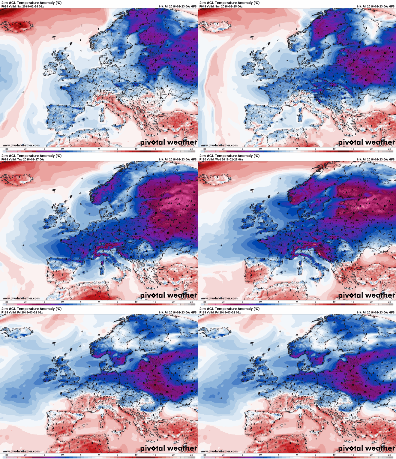
Animation of temperature differences from normal predicted by GFS model over the next week. (Pivotalweather.com)
The most severe cold is forecast to concentrate in Eastern Europe and Scandinavia where temperatures of 10 to 20 degrees Celsius (18 to 36 degrees Fahrenheit) below normal are predicted.
The cold will be very impressive for its duration, not relenting for at least five to seven days over much of the continent. While temperatures may moderate in southern Europe in about a week, long-range models show the cold persisting in northern and Eastern Europe for 10 days or longer.
“Very cold air from #Siberia will gradually spread across #Europe and the #UK during the coming days,” tweeted the Met Office, the Weather Service for the United Kingdom. “Factor in the wind and it will be feeling bitter for all of us”
Very cold air from #Siberia will gradually spread across #Europe and the #UK during the coming days. Factor in the wind and it will be feeling bitter for all of us pic.twitter.com/4HCfEnNdqb
— Met Office (@metoffice) February 23, 2018
The Met Office published a news release Friday that cautioned that it “will become increasingly cold, possibly exceptionally cold” early next week because of a stiff easterly wind and freezing wind chills. It also issued a yellow warning for snow in eastern and southeastern England, including London, late Monday through Tuesday. “Transport disruption is likely in areas with significant snowfall,” said Paul Gundersen, a Met Office forecaster.
High temperatures in London next week will mostly hover near or just above freezing (0 to 4 Celsius or in the 30s Fahrenheit), with lows of minus-2 to minus-5 Celsius (in the 20s Fahrenheit). The gusty winds will make it feel several degrees colder.
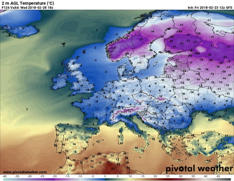
Forecast temperatures Wednesday afternoon across Europe from GFS model, in Celsius. (PivotalWeather.com)
France also is expecting its coldest weather of the winter, and natural gas prices spiked in response. “French power prices for the week ahead traded at the highest levels for this time of year since at least 2008,” Bloomberg News reported.
Meteo France, France’s weather agency, released a special statement about the cold, warning that temperatures will be as much as 10 degrees (18 Fahrenheit) below seasonal norms. “Such values are quite remarkable at this time of the year,” it said (translated from French). “It is often necessary to go back to the cold wave of end of February / beginning of March 2005 to find temperatures as low as or even more at the same time.”
Here are some 10-day forecast for European vacation destinations — assuming you like freezing cold and snow. Paris, Berlin and Rome (degrees-Celsius) from ECMWF 12z (https://t.co/iL4X4D0yi5) pic.twitter.com/G8R0y8NAIS
— Ryan Maue | weather.us (@RyanMaue) February 23, 2018
Temperatures in Paris may not rise above freezing either Tuesday or Wednesday.
A massive area of high pressure building over Scandinavia and a forecast for it to strengthen is the culprit for the cold. Winds flow around such high-pressure systems clockwise, drawing air from Siberia over Europe; hence the moniker “beast from the east.”
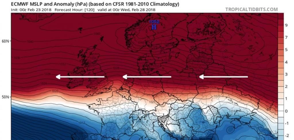
European model projection of enormous area of high pressure over Scandinavia Tuesday night. Clockwise winds around it will draw air from Siberia over much of Europe. (Tropicaltidbits.com, adapted by Capital Weather Gang)
This Arctic high-pressure system is a consequence of a sudden warming of the stratosphere that occurred in the high latitudes of the Northern Hemisphere last week. “This warming of the layer about 30,000 feet high near the North Pole can trigger a chain of events that results in a cold pattern over the middle latitudes in the weeks that follow,” wrote Capital Weather Gang’s Matt Rogers.
The resulting atmospheric pattern, known as the negative phase of the North Atlantic Oscillation, is forecast to fall to record low levels as February turns to March — a reflection of the extreme nature of this weather configuration. This same pattern could also turn conditions in the Mid-Atlantic and Northeast United States cold and stormy in about seven to 10 days.
While colder than normal air spills over the continents in Northern Hemisphere, it is evacuating the Arctic where temperatures are forecast to rise more than 45 degrees above normal in some areas this weekend into next week.
Courtesy/Source: Washington Post


