


November 18, 2016
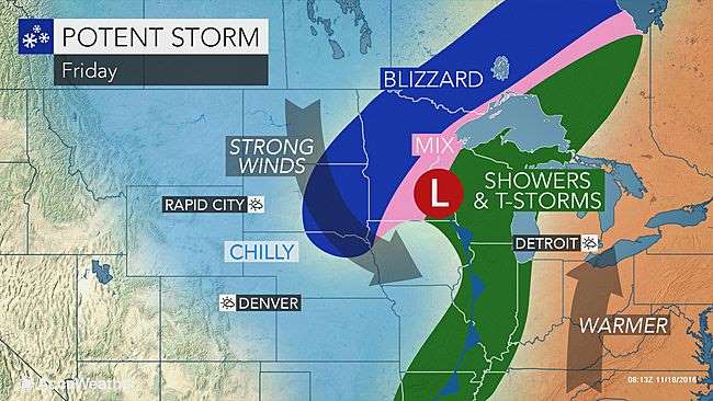
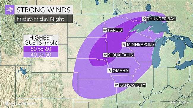
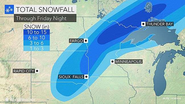
High winds, heavy snow and localized blizzard conditions will continue across the midwestern United States into Friday night. Heavy snow will shift from Nebraska and South Dakota to portions of Minnesota and Ontario on Friday.
November 18, 2016
High winds, heavy snow and localized blizzard conditions will continue across the midwestern United States into Friday night. Heavy snow will shift from Nebraska and South Dakota to portions of Minnesota and Ontario on Friday.
"The heaviest band of snow is expected to stretch from eastern South Dakota to northern Minnesota and north of Lake Superior in Ontario," AccuWeather Meteorologist Faith Eherts said. "Snow in parts of this swath may reach or exceed 12 inches (30 cm)."
There will be a sharp variation in snowfall on the northern and southern fringes, where a few miles may mean the difference between a couple of inches of snow and more than half a foot.
Blizzard conditions may unfold across these areas as wind gusts in excess of 40 mph howl from the north and northwest.
The combination of heavy snow and high winds will lead to blowing and drifting snow, near-zero visibility and extremely dangerous travel along area roadways.
The weight of the snow combined with the gusty winds can lead to sporadic power outages and broken tree limbs.
Snowfall rates could exceed an inch or two per hour in the heaviest bands of snow. At this rate, roads will quickly become snow-covered in spite of the warmth earlier this week.
There will be a zone where rain will mark the onset of the storm before changing over to snow later Friday. This encompasses portions of eastern Minnesota, northern Wisconsin and the Upper Peninsula of Michigan.
Those traveling Friday evening should be extra cautious as wet roads can quickly become slippery once the sun sets and temperatures plummet. This includes in Minneapolis.
Snow will begin to wind down from southwest to northeast across the region during Friday night. Sunshine will return for snow removal operations this weekend.
Before reaching the central U.S., the snowstorm left its mark on portions of the interior West on Thursday.
Over 13 inches of snow was reported near Lander, Wyoming.
Denver received its first flakes of the season on Thursday. The city fell shy of breaking the record for the latest recorded first snowfall of the season. The record stands at Nov. 21, 1934.
The snow resulted in a 20-car pileup along Interstate 70 near Evergreen, just outside of Denver. Two people were hospitalized, and parts of the highway were closed at multiple times throughout the evening.
Courtesy: AccuWeather


