


March 25, 2016
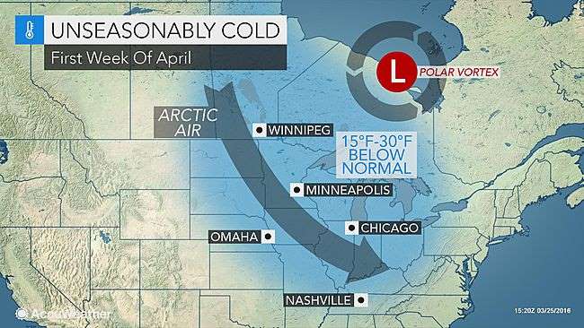
Arctic air will plunge into much of the central and eastern United States, as the polar vortex shifts its position during early April.
Following a pattern favoring more warm days than cold days into next week, a change will likely bring record cold to parts of the Midwest and East.
March 25, 2016
Arctic air will plunge into much of the central and eastern United States, as the polar vortex shifts its position during early April.
Following a pattern favoring more warm days than cold days into next week, a change will likely bring record cold to parts of the Midwest and East.
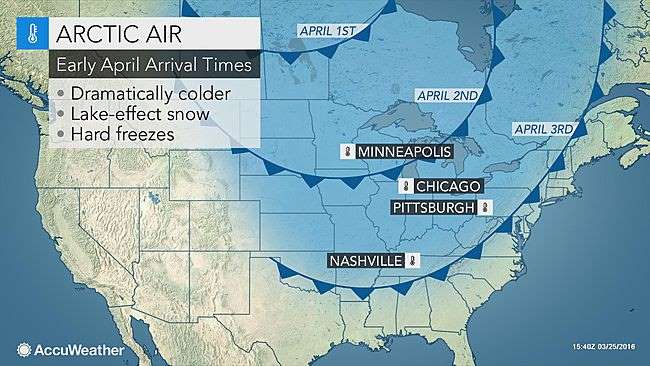
"The polar vortex will drop into Ontario during the first weekend in April," according to AccuWeather Long-Range Meteorologist Joe Lundberg.
This means arctic air will have a direct path into the Midwest.
"From Sunday, April 3, through the following week, most of, if not all, days will bring below-average temperatures from the northern Plains to the mid-Atlantic coast," Lundberg said. "We expect nighttime temperatures to drop to freezing as far south as the Tennessee Valley."
Temperatures will average 15-30 degrees Fahrenheit below normal with the core of the cold air directed at the North Central states. Normal highs during the first week of April are in the lower to middle 50s in Minneapolis, Chicago and Detroit and in the 60s from Kansas City, Missouri, to Nashville and Cincinnati.
"The intense cold could impact play for opening day MLB games in Pittsburgh and Kansas City, Missouri, on Sunday, as well as games elsewhere in the Midwest and Northeast on Monday," according to AccuWeather Lead Long-Range Meteorologist Paul Pastelok.
AccuWeather RealFeel® Temperatures could plunge into the single digits at times in part of the Upper Midwest and northern Plains.
The cold blast could spell peril for blossoming fruit trees and shrubs from parts of the Ohio and Tennessee valleys as well as portions of the Northeast.
"There is concern for the cold to damage fruit trees that are in blossom or have already blossomed, including apple, pear, plum, cherry and peach varieties," according to AccuWeather Senior Meteorologist Brett Anderson.
Playlist used for trending content.
It is the actual temperature and not the RealFeel that has an impact on the blossoms.
How low the temperature gets at night will depend on wind and cloud cover. Light winds and clear skies often allow cold air to collect near the ground. A breeze mixes the air, while cloud cover can act as a blanket and keep temperatures several degrees higher.
The blast of cold air is likely to trigger unusually heavy lake-effect snow for April. The snow could be heavy enough to disrupt travel on the highways immediately south and east of the Great Lakes.
The cold air will run into some resistance along the Gulf Coast and east of the Appalachians. In these areas, it will be chilly for early April, but not as extreme as the Midwest cold.
For a few days during the first week of April, highs could be in the 40s in New York City and perhaps in the 60s in New Orleans. It is possible that before the arctic air leaves the U.S., it pivots eastward across New England and to the Northeast coast for a couple of days.
"On or around April 10, the pattern will change and the second half of April will be warm [in the Central and Eastern states]," Lundberg said. Temperature departures will not be as high as they were in March and other months of the winter.
AccuWeather will continue to provide updates on the arctic blast in the days ahead.
Courtesy: AccuWeather


