


December 17, 2015
A series of storms more typical of spring will bring rounds of drenching rain to much of the eastern third of the nation during the week of Christmas.
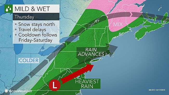
A storm swinging through the East on Thursday may be just a small taste of the wet weather to come during the fourth week of December, in terms of rainfall and related travel problems.
December 17, 2015
A series of storms more typical of spring will bring rounds of drenching rain to much of the eastern third of the nation during the week of Christmas.
A storm swinging through the East on Thursday may be just a small taste of the wet weather to come during the fourth week of December, in terms of rainfall and related travel problems.
Colder air will follow in the wake of Thursday's storm and will briefly set up locally heavy lake-effect snow into this weekend.
However, the cold air will not stick around long.
According to AccuWeather Chief Meteorologist Elliot Abrams, "Enough warmth will rebuild in the East to keep snow out of the picture next week."
The storms will bring rounds of rain, drizzle and fog from part of the Mississippi Valley to the Atlantic Seaboard during the fourth week of December.
If the weather was cold enough, the storms could bring 1-2 feet of snow next week. For this to happen, the temperature would have to be 20-30 degrees Fahrenheit lower in many cases. In fact, record warmth is possible, especially along the Atlantic Seaboard.
Instead, enough rain can fall at times to raise the potential for flash and urban flooding in some communities and force motorists to slow down on the highways. The combination of rain and a low cloud ceiling may also induce airline delays at times.
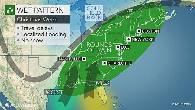
The weather will be warm enough and the systems strong enough to bring rare December thunderstorms to parts of the East and South.
There is also the chance of severe weather.
AccuWeather Chief Long Range Meteorologist Paul Pastelok said that while confidence is high with the overall warm and wet pattern, trying to time each storm beyond a few days in advance is challenging in this case.
One scenario favors one or two strong storms, which would increase the risk for a severe weather outbreak and flooding that could also threaten lives and property. This scenario would allow more of a gap between storms and the potential for a big storm on Christmas Eve and Christmas Day.
"Only if a big storm unfolds would there be a coating of snow in parts of the central Appalachians and the eastern Great Lakes region on Christmas Day," Abrams said.
Another scenario favors multiple weak storms with no severe weather and more modest rainfall. This scenario would be more of a long-term inconvenience for travelers and last-minute shoppers.
No matter what the number of storms and their strength, people should be able to leave the heavy winter clothes in the closet. People should also have an umbrella handy and a good set of windshield wipers to assist with the wet weather for the week of Christmas.
While major travel delays seem unlikely due to rain in the East, there will likely be some delays at airports and conditions on the roads that may slow travelers.
For fans heading to bowl games after Christmas, indications are the stormy and wet pattern will continue.
Courtesy: AccuWeather


