


MAY 10, 2025
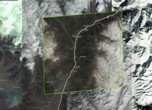
Images of Indian regions for which orders were placed with Maxar Technologies, a top US-based space tech company | Photo: Maxar
New Delhi: Two months before terrorists killed 26 people in Kashmir, a top US-based space tech company saw an unprecedented spike in orders for high-resolution satellite images of Pahalgam and its surrounding areas. Between 2 and 22 February 2025, at least 12 orders—double the usual number—were placed with Maxar Technologies, whose roster of clients includes government and defence agencies across the world. Orders for Pahalgam satellite images started appearing on the portal in June 2024, just months after Maxar acquired a new partner: A Pakistan-based geo-spatial company linked to federal crimes in the US.
The data does not show whether the orders for Pahalgam satellite images were placed by the Pakistani firm, Business Systems International Pvt Ltd (BSI). But defence analysts and experts as well as scientists that ThePrint spoke to said the coincidence cannot be dismissed given the track record of the company’s founder, Obaidullah Syed.
The Pakistani-American businessman was found guilty and sentenced to a year in prison by a US federal court for illegally exporting high-performance computer equipment and software application solutions from America to the Pakistan Atomic Energy Commission (PAEC) — the agency that designs and tests high explosives and nuclear weapon parts, and develops solid-fuelled ballistic missiles.
“The very fact that a Pakistani company was taken on as a partner by Maxar without any background check is alarming,” said a source who has subscribed to Maxar services. “India should pressure such satellite imaging and data companies to stop operations with Pakistan,” added the source.
Maxar’s portal that ThePrint was given access to showed that apart from Pahalgam, satellite images also showed parts of Pulwama, Anantnag, Poonch, Rajouri, and Baramulla—all militarily sensitive regions in India. The cost of each satellite image starts at Rs 3 lakh, and increases in proportion to the resolution.
“Satellite surveillance has become the backbone of any country’s intelligence. While it is unclear whether these images could have been used for planning the April 22 attacks in Pahalgam, India could ask Maxar to conduct an investigation into the ordered images,” said an ISRO scientist.
These high-resolution images are often used by defence agencies for monitoring troop movements, weapon installations, and infrastructure development, detecting illegal border crossings, unauthorised incursions and smuggling, etc.
Lieutenant General AK Bhatt (retd), former Director General of Military Operations and currently Director General of the Indian Space Association (ISpA), said easy availability poses the risk of high-resolution satellite images being misused by rogue elements.
“Commercial availability of high-resolution satellite images with many proliferating private space companies world over has improved ISR (intelligence, surveillance and reconnaissance) capabilities of nations and armed forces, but equally created vulnerability, if used by rogue elements and non-state actors,” Bhatt said.
Orders placed
Maxar Technologies is known for its satellites that provide high-definition images with pixel resolution ranging from 30 cm to 15 cm. The smaller the pixel size, the better the clarity of the image.
In India, government agencies such as the Ministry of Defence and the Indian Space Research Organisation (ISRO) are clients of various Maxar services. At least 11 Indian space tech startups and companies are customers and partners of Maxar Technologies.
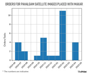
Orders from different satellite frequency ranges for Pahalgam peaked in February 2025 with purchases made on the 12th, 15th, 18th, 21st, and 22nd. In March, there were no orders. An order was placed on 12 April — ten days before the terror attack. In the days that followed, there were two requests for satellite images of the region — on 24 and 29 April. No orders have been placed since.
The data accessed by ThePrint does not mention the resolution of the satellite images or which company or country made the purchases.
“Anyone who is a paying partner with Maxar can see the satellite images that other partners order — unless these images hold strategic importance, in which case it is a confidential exchange,” said another Maxar service subscriber who did not wish to be identified. While the images and the date of orders can be accessed, their source cannot be traced without Maxar’s permission, which it doesn’t allow for ‘confidentiality’ reasons.
ThePrint reached out to Maxar Technologies via email but did not receive a response.
A defence expert explained that some precise, high-resolution satellite images can give such minute details that it can be used to conduct facial profiles of people walking on the streets.
“Anything under 10cm resolution is really sharp and requires special permission from the country whose images are being accessed. But the problem is that even a 30cm resolution can give you a pretty clear view of the infrastructure in an area,” the expert said.
Pakistani firm with a dodgy rap sheet
BSI becoming a partner with Maxar Technologies is cause for concern.
While most of Maxar’s partners are also their customers, a partner plays a distinct role as product developer, reseller and solution integrator on behalf of Maxar.
BSI has a criminal past, according to the US Department of Justice. It acted as a middleman for illegally routing resources for the Pakistani government agencies.
Obaidullah Syed, who also founded the Chicago-based BSI USA, pleaded guilty in 2022 for exporting goods from the US without licence from the Department of Commerce and submitting false export information from 2006 to 2015.
He was sentenced to a year and a day in federal prison. Prior to sentencing, Syed forfeited $247,000 of criminally derived funds to the US government, according to a media release by ICE (US Immigration and Customs Enforcement)
Federal agencies hailed the judgement.
“Let this be a reminder to our adversaries that the United States will stop at nothing to protect and defend our national security,” the Homeland Security Investigations special agent in charge in Chicago said at the time.
US agencies also expressed alarm over the back-channelled business dealings of Syed with the Pakistan Atomic Energy Commission. This concern was voiced during the trial because of the nature of PAEC’s operations. ICE, in its report, said that between 2006 and 2015, Syed misrepresented that the computer equipment his company was exporting from the US was for state-based universities and his businesses, when, in fact, it was utilised for PAEC’s use.
“The PAEC is a Pakistani government agency designated by the US government as an entity which may pose an unusual or extraordinary threat to the national security, foreign policy, or economy of the United States,” the US agency report read.
Syed continues to be the contact person for BSI on the Maxar portal.
BSI, according to its official website, is headquartered in Karachi, with branches located all over Lahore, Islamabad, and Faisalabad. It claims to have been operational since 1980, and deals in “high performance computing, data mining, Geographical Information System (GIS), command and control systems and computational fluid dynamics” among other services.
Mails sent to the registered email id of BSI Pakistan bounced back, and messages sent on their official LinkedIn profile went unanswered.
No obligation on Maxar
The Pahalgam purchase orders caught the attention not just of Indian subscribers, but also a few ISRO scientists. India’s space agency subscribes to Maxar services.
In India, the regulations regarding high-resolution satellite imagery, especially concerning security-sensitive areas, come under the government’s Remote Sensing Data Policy, Geospatial Data Guidelines, and the Spacecom Policy. The rules currently allow access to geospatial data with limited restrictions on general use.
For high-security regions—military installations, border areas, and nuclear sites—access is restricted, blurred or only available at reduced resolution.
“The problem is that they (Maxar) are a business enterprise. They will provide services to anyone who is paying them,” said the ISRO scientist.
Since India is still setting up its systems, with more surveillance satellites set to be launched in the coming years, it is still dependent on foreign service providers for high-resolution satellite images.
“Of course, there are challenges when you depend on a third party for surveillance data. They have no obligation to be loyal to you,” the ISRO scientist added.
Courtesy/Source: The Print / PTI


