


NOVEMBER 11, 2023
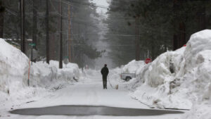
A man walks his dog on a snow covered street as snow begins to fall during an atmospheric river on March 21, 2023 in South Lake Tahoe, California. – Justin Sullivan/Getty Images
A major pattern change is set to deliver California’s first atmospheric river of the season next week. Significant rain and snow is in the forecast for the Golden State, while damp, dreary days are ahead for other parts of the West as signs of El Niño’s influence on the upcoming winter season emerge.
November got off to a wet start across the Pacific Northwest, but the rainy weather didn’t make it south into much of California. Two things will bring a dramatic change to that trend next week: a southward dip in the jet stream – the river of fast-moving air that carries storms around the planet – will be pointed directly at California; and a large area of disruptive atmospheric energy will linger just off the West Coast.
Next week’s storms will be fueled in part by an atmospheric river – the region’s hallmark type of winter storm, which transports abundant moisture from the tropical Pacific straight to the West Coast.
The West was drenched by many of these systems last winter: California alone saw at least a dozen significant atmospheric rivers, which claimed at least 18 lives and dealt tremendous damage to infrastructure. But they also brought much-needed rain and snow to a region that desperately needed it, filling reservoirs and allowing water officials to take stock and prepare for a future with less freshwater.
Atmospheric rivers are categorized on a five-point scale, with 1 describing “weak” storms and 5 classified as “exceptional.” Next week’s event is shaping up to be at least a Level 2 of 5 – in other words, a “moderate” atmospheric river.
Rain will push into Northern California as early as Monday, spreading to parts of Central California on Tuesday. The timing for rain in Southern California depends strongly on the exact evolution of the storm early next week, but wet weather will likely commence by late Wednesday or Thursday.
Once rain begins, it will continue at varying intensity for much of the week and into the weekend for some areas. Rainfall amounts are not expected to reach catastrophic levels that would trigger widespread flooding, but many locations could receive more than a month’s worth in a matter of days.
Any rain that falls will be notable – California hasn’t experienced multiple days of rain since the summer, and many locations are in a rainfall deficit compared to average.
From September 1 to November 9, San Francisco and Los Angeles have each only recorded about 6% of the average rainfall for the period. Despite this rainfall deficit, California is drought-free for the first time in nearly four years: the state reported no areas of drought in mid-October, which was the first such reading since January 2020.
Rain isn’t the only concern next week – the stormy setup is primed to deliver significant snow to the Sierra Nevada mountain range.
Multiple feet of snow could fall in the highest elevations of the Sierra, with up to a foot in some foothills by next weekend. The elevation where rain will change to snow will start out quite high next week, but snow will likely begin to pile up in the lower elevations of the mountains in earnest late-week as colder air is pulled across the region.
Elsewhere across the West, there will be no discernible break from the dreariness with the new influx of wet weather next week, and the Northwest will remain wet both this weekend and next week as moisture continues to funnel across the region.
El Niño and atmospheric rivers are linked
Like many other elements of the upcoming winter – including temperature and snow – studies have shown that El Niño influences the behavior of atmospheric rivers.
A 2017 study found atmospheric rivers are more likely to impact the western US during El Niño, when ocean temperatures in the tropical Pacific are abnormally high.
Not only can El Niño affect where atmospheric rivers dump the most precipitation, its strength can also affect how often they occur. A study published in January found the frequency of atmospheric rivers increased during strong El Niño years – the level expected this winter.
Like any weather phenomenon, atmospheric rivers aren’t dependent on just one variable. So, having a strong El Niño in place doesn’t necessarily guarantee a higher frequency of atmospheric river events.
For example, the 2017 study also found that atmospheric rivers are less likely to impact the western US during La Niña. But La Niña was firmly in place last winter when California was slammed by a dozen of the potent storms.
Courtesy: CNN


