


JUNE 9, 2023
‘Biparjoy’, the ‘very severe’ cyclonic storm spiralling in the Arabian Sea, is likely to gain intensity over the next three days but remain away from the Indian coast as it moves north-northwestwards. The powerful storm has been rapidly intensifying with warm sea temperatures fuelling its strength, said the India Meteorological Department.
“We do not expect any direct impact on the coastal areas as of now. The latest forecast shows that the cyclone is likely to move north and north-westwards away from the coast. At present, there is no such forecast that it will come close to the coast,” Dr. KS Hosalikar, senior scientist and head of IMD Pune told News18.
“But the warnings for fishermen are in place, and due caution must be exercised along the west coast since the seas are rough,” he added.
As on Thursday afternoon, the storm continues to rage in the east-central Arabian Sea with an intensity of a ‘very severe’ cyclone. Gale winds of 135-145 kmph and gusting up to 160 kmph prevail over the seas, and are likely to peak up to 170 kmph by June 10. According to the MeT, the cyclone is set to remain ‘very severe’ at least till June 13.
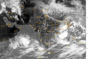
Scientists tracking the storm said it lay centred about 850 km west-southwest of Goa, 890 km southwest of Mumbai, 900 km south-southwest of Porbandar as on Thursday afternoon. It has moved nearly northwards over the past few hours. The latest forecast shows that it will intensify gradually in the next 24 hours and move nearly north-northwestwards during the next three days.
Rough seas along the west coast
Though the cyclone is several hundred kilometres away from the west coast, Goa, Karnataka, Maharashtra and Gujarat have been put on alert. Scientists highlighted that there might not be any direct impact but since the seas are rough, there should not be any fishing operations in the designated areas till the storm settles down after June 14.
Sea conditions are likely to be rough along and off Karnataka-Goa-Maharashtra and eventually the Gujarat coast from June 11. Fishermen have been advised not to venture into the central Arabian Sea till June 13, and adjoining areas of north Arabian Sea from June 12 to 14. Those out at sea have been advised to return.
“Even though it is far away from the coast, the cyclone is set to become more severe with gale winds reaching 160 kmph in the seas. When such a strong system develops in the adjoining seas, we can expect squally weather on the coastal land,” Hosalikar added.
The IMD has predicted 35 to 45 kmph winds gusting to 55 kmph along and off Maharashtra-Gujarat coast over the next 3 to 4 days.
Rapid intensification of cyclones
Cyclones in June in the Arabian Sea are not that unusual. But the warm sea surface temperatures have been fuelling intense storms in the Indian Ocean, with the cyclones intensifying faster than ever before. Recent studies also point towards an increasing trend in the intensity, frequency and duration of cyclonic storms and ‘very severe’ cyclonic storms over the Arabian Sea.
In case of ‘Biparjoy’, the low pressure area formed over southeast Arabian Sea on the evening of June 5 and intensified into a depression within 12 hours. By around 11.30 am on June 6, it had intensified into a deep depression over southeast and adjoining the east-central Arabian Sea. By 5.30 pm on June 7, it turned into a cyclonic storm. And within the next 12 hours, it became a ‘very severe’ cyclonic storm over the same region.
“The oceans have become warmer already on account of climate change. In fact, recent study shows that the Arabian Sea has warmed up by almost 1.2 degrees Celsius since March, thus conditions are very much favourable for the rapid intensification of the system so it has potential to sustain the strength for a longer period,” said Professor Raghu Murtugudde from IIT Bombay.
Courtesy/Source: News18 / PTI


