


JULY 25, 2022
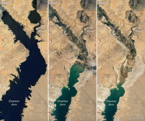
Satellite images of Lake Mead on July 6, 2000 and July 3. (earthobservatory.nasa.gov)
New satellite images from NASA show Lake Mead’s dramatically shrinking shoreline and how parts of the once-sprawling reservoir have mineralized over the past two decades.
Lake Mead, the largest reservoir in the nation, sits at just 27% capacity, its lowest point since April 1937 when it was first being filled, according to NASA.
The lake, on the Nevada-Arizona border, is nearly unrecognizable from how it looked just 22 years ago, according to photos released by NASA Wednesday.
An image taken from space on July 6, 2000, shows the lake full and a deep shade of blue. Another photo, taken July 3, shows a lighter color, meaning areas formerly underwater have mineralized, a phenomenon known as a “bathtub ring” effect.
At the end of July 2000, around the time of the first satellite image, the water elevation at the Hoover Dam was at 1,199.97 feet above sea level. By July 18 this year, around the time of the second image, it dropped to 1,041.30 feet, according to data from the U.S. Bureau of Reclamation.
Another photo from 2021 shows the Virgin River, which connects to the Overton Arm of Lake Mead, mineralized. The year before, the river was completely filled with water.
The lake is drying up due to climate change and severe drought, according to NASA.
“The largest reservoir in the United States supplies water to millions of people across seven states, tribal lands, and northern Mexico. It now also provides a stark illustration of climate change and a long-term drought that may be the worst in the U.S. West in 12 centuries,” NASA said.
The lake has a maximum capacity of 1,220 feet in elevation, a level last approached in 1983 and 1999, according to NASA.
Today, the lake is perilously close to dead pool status, when the reservoir dips below 895 feet and is so low that water cannot flow downstream from the Hoover Dam. However, experts say that’s a possibility still years away.
As the lake has receded, waters once frequented by visitors have dried up and unveiled long-sunken secrets, including a body found in a barrel, a World War II-era ship and pleasure boats.
Due to the declining water levels and “20 years of ongoing drought,” five of six boating ramp sites are closed at Lake Mead, the National Park Service said.
The lake gets most of its water from snow-melt in the Rocky Mountains that flows down the Colorado River watershed through Lake Powell, Glen Canyon and the Grand Canyon. Snow-pack from last winter was below average levels in some areas, NASA reported.
Lake Mead isn’t the only area seeing the ramifications of drought.
In total, 74% of nine Western states face some level of drought with 35% of the area in a state of extreme or exceptional drought, according to NASA.
Further, the entire Colorado River system, of which Lake Mead is a part, stands at just 35% capacity, reclamation bureau data shows. This system provides electric power and water to roughly 40 million people, including the cities of San Diego, Las Vegas, Phoenix and Los Angeles.
Last month, the bureau issued an emergency request to states in the Colorado River basin to reduce water use to prevent the system from further depleting.


