JANUARY 12, 2022

Snow forecasted in D.C. area on Sunday, Jan. 16, 2022
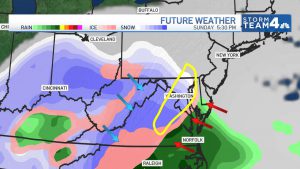
A storm looks likely to hit the Washington, D.C., area during part of Martin Luther King Jr. Day weekend, and there’s a chance for snow Sunday into Monday.
Forecasting this storm is tricky because the American and European weather models differ on whether this storm will be more rain or more snow for D.C., Storm Team4 says.
The bottom line: Be ready for some amount of snow between Sunday and Monday.
The storm’s track will determine where there will be snow, rain or a wintry mix.
As of Wednesday, Storm Team4 says you’ll most likely see snow shift to a wintry mix. There’s a 30% chance for a straight snowstorm and a 10% chance the D.C. area will only see rain.
We are still more than 4 days away from the first flakes but it it starting to look more likely than not that our area will have a winter storm to deal with Sunday afternoon/evening into Monday. Too early for predicting exact amounts but it’s never too early to start storm preps. pic.twitter.com/Ds4WBWAvI5
— Chuck Bell (@ChuckBell4) January 12, 2022
Before the storm, the weather will be mostly dry and chilly: Expect highs in the 40s on Wednesday and Thursday, then colder weather Friday and Saturday.
Another shot of Arctic air arriving in the D.C. area Friday will cause temperatures to fall through the afternoon and push in the cold needed for Sunday’s snow chance.
There is agreement among the forecast models that a coastal storm would form off the North Carolina coast Saturday night and impact the D.C. area Sunday evening into Monday.
With cold air in place as the storm comes up the coast, Storm Team4 says snow is likely late Sunday into Sunday night. The American and European models agree snow is likely at the start.
A change to rain, or a rain-snow mix, could occur early Monday morning as it warms up.
There’s good news and bad news about the Sunday-Monday storm chance. The good news is that there is higher confidence that a storm is going to occur. The bad news is that it looks like the rain/snow line will be in play. Stay with @nbcwashington for updates between now and then. pic.twitter.com/HSdcfD0PIU
— Chuck Bell (@ChuckBell4) January 12, 2022
The storm system will move on quickly and likely clear out by mid-morning Monday.
Any westward shift in the storm’s track will bring the rain-snow line more into play for areas along and east of Interstate 95.
Where that rain-snow line falls determines who gets a winter wonderland or just plain wet weather.
It’s possible several inches of snow — perhaps 6 inches or more — will fall in parts of the D.C. area that get a full snowstorm. Stay with Storm Team4 this week for regular updates. The forecast will become much clearer between now and Sunday.
Courtesy/Source: NBC WDC


