

 across Major Indian Cities: Check 24K, 22K, 18K prices in Delhi, Mumbai, Kolkata, Chennai, Lucknow and other major cities")


MARCH 7, 2020
Spring fever alerts may have to be issued across the bulk of the United States in the coming days as warm air builds from the Great Plains to the Eastern Seaboard.
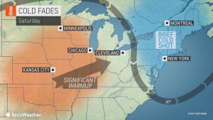
High pressure sitting over the eastern two thirds of the country will provide dry conditions and springlike warmth to these areas this weekend.
“Even though most record highs this time of the year are likely to be out of reach during the warmup, temperatures will still surge to well-above-average levels,” stated AccuWeather Meteorologist Alex Sosnowski.
Average temperatures for early March are in the 30- to 40-degree Fahrenheit range from the northern Plains into the Northeast. From the central Plains into the mid-Atlantic, average temperatures in the the 40s and 50s.
After rounds of downpours and severe weather in previous weeks, tranquil weather will be welcomed by residents across the southeastern U.S. A quiet pattern this weekend will also assist those still recovering from the tornadoes that ripped through Tennessee earlier this week.
Southerly winds on the western side of the high will carry warmer air north across the Plains. Afternoon high temperatures are expected to top out in upper 60s and lower 70s from southern South Dakota to northern Oklahoma. Temperatures in the lower to middle 60s are expected into western Iowa.
Gusty winds accompanying the warmup will also increase the risk for brush fires in parts of the central Plains. Winds out of the south and southwest will be moisture-starved, and any fires that spark in this region could spread rapidly in these conditions.
While temperatures will plummet through the overnight hours under clear skies, afternoon temperatures will rebound again on Sunday.
“Temperatures could make a run into the lower 70s over part of the Ohio Valley by Sunday. Even Chicago and Detroit can expect temperatures near 60 on Sunday,” added Sosnowski.
After ending the week with a high of 39 degrees Fahrenheit, highs in Minneapolis are expected to reach the middle 50s on Saturday and then the middle 60s to end the weekend.
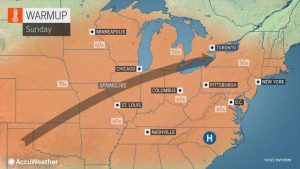
Warmer conditions will also expand into the eastern U.S. on Sunday as the area of high pressure shifts east and winds turn out the south.
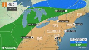
The highest temperatures of the week for the Northeast are expected on Monday, peaking at about 60, as far north as southern New England with high temperatures closer to 70 in the mid-Atlantic.
“Boston and New York City can expect highs in the 60s on Monday, and temperatures have a chance of reaching 70 in Philadelphia and may reach the upper 70s in Richmond, Virginia,” said Sosnowski.
Given that such a vast stretch of the area from the Plains to the mid-Atlantic and southern New England has no snow on the ground, there is the potential for this warmup to overachieve and exceed forecast high temperatures by several degrees, according to AccuWeather meteorologists.
Breezy conditions will follow the peak of the warmth and will add a coolness to the air. Despite plenty of sunshine, AccuWeather RealFeel® Temperatures may be similar to the actual temperature in some locations. This will be especially true in locations to the north and east of large bodies of cooler water.
The springlike warmth will be squashed across the Plains to start the week as a storm system begins to organize over the region. The storm will bring an end to warmup in the East by the middle of the week.
Courtesy/Source: AccuWeather


