


APRIL 25, 2020
Old Man Winter will take yet another parting swipe at the northeastern United States, meteorologists say, with more accumulating snow forecast for some of the higher elevations.
The region will be between storms on Saturday, following wet weather into Friday night and ahead of another storm heading in for the latter part of the weekend.
Most of the region can expect a decent day Saturday.
“Saturday will be the day for a break outside by way of a walk or jog while social distancing,” AccuWeather Meteorologist Dean DeVore said.
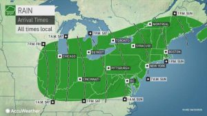
The same storm expected to produce a round of severe weather from Oklahoma and Arkansas to the Carolinas this weekend will spread rain from southwest to northeast spanning Saturday evening over the central Appalachians to Sunday evening over eastern New England.
“Much of the Northeast will suffer another setback of colder air just as the storm pivots up from the South during the second half of the weekend,” said DeVore.
“The entire storm will be in the form of rain, drizzle and unwanted chill in the corridor from Washington, D.C., to Philadelphia, New York City and Boston,” DeVore added.
AccuWeather RealFeel Temperatures can dip into the 30s F at times, even in the larger cities, factoring in wind, rain and other conditions on Sunday and Sunday night.
Enough cold air will be injected into the region not only to make it chilly, but also to allow snow to fall and accumulate over the higher elevations from northern Pennsylvania to Maine. The cold air will allow some wet snow to mix in at intermediate elevations and perhaps the valley floors in the same swath from Sunday night to Monday.
“Most of the accumulating snow will fall at elevations near and above 2,000 feet in the region,” AccuWeather Senior Meteorologist Brett Anderson said.
There are not many well-traveled roads that go that high up, but motorists venturing over the highest ridges in the region over the central and northern Appalachians could encounter some slush.
“A general 1-3 inches of snow is forecast above 2,000 feet with an AccuWeather Local StormMax of 8 inches over the highest elevations in New York state and northern New England,” Anderson said.
Some trees and power lines that extend over the higher elevations, and especially the ridges, can be weighed down to the point of causing sporadic power outages.
The ongoing and reoccurring chill in the region is begin caused by a persistent southward dip in the jet stream.
While the polar vortex set up shop for a time near Hudson Bay a couple of weeks ago, it has since departed. However, pockets of cold air remain and can continue to develop in place as long as the overall jet stream remains suppressed to the south.
“It appears as though the jet stream will tend to flatten out more and take on a nearly straight west to east configuration during May, but there will still be some reoccurring or persistent southward dip in the Northeast,” AccuWeather Lead Long-Range Meteorologist Paul Pastelok said.
As long as that continues to happen, warmups can occur, but they will be brief with more setbacks of cool or chilly air to come, especially farther toward the northeastern corner of the nation, such as New England.
Farther to the west and south, over the Plains and Midwest, warmups will be more frequent and longer lasting.
Although quite rare, snow has fallen and accumulated into late May in the northern tier of the Northeast over the higher elevations. It has also snowed and accumulated in parts of the central Appalachians into early May.
Around New York City, the last reported inch of snow or greater was on April 25, 1875, when 3 inches fell on Central Park. The latest snowflakes, or frozen precipitation, of the season were observed was on May 9, 1977.
Snowflakes or some sort of frozen precipitation have been observed on the last day of May at both Burlington, Vermont, in 1945, and Caribou, Maine, in 1961.
It has snowed every month of the year on Mt. Washington, New Hampshire, which is at an elevation of approximately 6,300 feet above sea level.
Courtesy/Source: ACCUWEATHER


