


SEPTEMBER 5, 2019
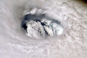 Hurricane Dorian’s eye seen from the International Space Station. – Photograph by NASA
The same perennially warm waters that attract tourists to the Bahamas also helped sustain one of the most destructive storms ever seen in the region.
For more than a day Hurricane Dorian stalled over the Bahamas, where it unloaded 185 mile-per-hour winds at its peak, dumped intense rainfall, and inundated homes with storm surge.
What was a Category 3 storm on Friday quickly intensified into a Category 5 by Sunday. As it passed through the Bahamas on Monday evening, the same atmospheric system steering the storm toward Florida was interrupted, essentially leaving the storm without winds to propel it forward.
The rapid growth was fueled by what NASA described as “storm-fueling waters” around southern Florida and the Bahamas.
It was essentially “really bad luck,” says Philip Klotzbach, a meteorologist at Colorado State University. “You happen to have an unusual steering pattern at the same time as a major hurricane.”
The climate change connection
Disastrous and record-breaking storms often generate debate about how much climate change may have played a role.
Both Klotzbach and University of Miami meteorologist Brian McNoldy say linking any one storm to massive global change is challenging, and so is linking Hurricane Dorian to climate change.
Scientists instead look at patterns to assess how storms are changing over time.
The fourth National Climate Assessment predicted hurricanes could become more intense and destructive as the climate warms. Some studies suggest a warming atmosphere could make for slower winds, and research is increasingly showing that warmer conditions make hurricanes slower and wetter.
To understand why, it’s important to understand the link between warm water conditions and hurricanes.
Hotter and stronger
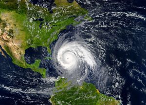
Tropical hurricane approaching the USA. Elements of this image are furnished by NASA.
When a storm stalls over land as with Hurricane Harvey in Houston in 2017 and Hurricane Florence in the Carolinas in 2018, it typically weakens quickly because it no longer has warm water to fuel it.
“That area over the Bahamas just cooks this time of year,” McNoldy says. “Hurricanes love it.”
He explains that both the temperature at the surface of the ocean and the depth of the warm water contribute to how strong a hurricane becomes.
“How strong a hurricane can get depends on how warm it is,” says McNoldy.
A hurricane begins as a cluster of thunderstorms over the ocean. Many begin off the west coast of Africa when a westbound jet stream called the African Easterly Jet blows across the eastern Atlantic. Seasonal temperature changes alter the jet stream’s latitude, which leads to low-pressure winds that move through the air as waves.
 Photo Taken In Phoenix, United States
The winds whip over the ocean, forcing water to evaporate and rise into the atmosphere where it cools, condenses, and forms storm clouds. An estimated 85 percent of major Atlantic hurricanes are born off the African coast.
When those storms are exposed to enough warm water and westbound winds, they can form what’s called a tropical depression, in which an area of drier, cooler air rushes to fill the void left by rapidly rising warm air.
In the Northern Hemisphere, storms spin counter-clockwise because of the Coriolis effect, a term that refers to how objects move across our rotating Earth.
Over warm water, the fueling tropical depression will suck up more warm, moist water vapor like a straw, making the system stronger and condensing the dry, low-pressure into the center. This is when a tropical storm forms. As the storm continues sucking up water vapor, it pushes more wind to the outer edges of the storm system, causing the wind to wick up more moisture and creating a feedback loop. If sustained, the low-pressure center in a tropical storm will form the eye of a hurricane.
According to NASA, ocean surface temperature must be about 79 degrees Fahrenheit for a hurricane to form, and a tropical depression is only upgraded to a hurricane when it reaches 74 mile-per-hour winds.
As we saw with Dorian in the Bahamas, heat will influence how tightly the hurricane itself spins, but it’s atmospheric winds that decide how quickly a hurricane will be pushed through the ocean. Warmer storms are also capable of dumping more rain because warm temperatures carry more water vapor.
 Coast house beachfront waterfront vacation home in Florida
Some of the strongest storms to hit the East Coast originate off Africa’s West Coast and travel across the Atlantic. If the storm encounters a patch of cold ocean water, the natural formation of the hurricane can slow and falter until the storm dissipates.
Like adding more fuel to a fire, warm water (whether heated by regular summer temperatures or greenhouse gases) make hurricanes stronger.
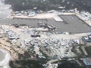
The Red Cross estimates that as many as 13,000 Bahamian homes have been destroyed or damaged in some way by Dorian, and storm surges ranging from 18 to 23 feet have flooded drinking wells, meaning residents will struggle to access fresh drinking water now that the storm has moved north.
Forecasters are now watching again to see how warm ocean water and wind conditions will fuel Dorian as the hurricane moves beyond the Bahamas and up the U.S. East Coast.
Courtesy/Source: National Geography


