


January 8, 2014
Our weather will remain cold through the weekend before the possibility of some wintry weather next week. However, if you’ve not been a fan of these below-average temperatures, we’re looking at the chance of a warm-up late in the two-week period.
January 8, 2014
Our weather will remain cold through the weekend before the possibility of some wintry weather next week. However, if you’ve not been a fan of these below-average temperatures, we’re looking at the chance of a warm-up late in the two-week period.
Frigid air is blowing across the United States on Thursday, dropping temperatures in many areas into the single digits and leading weather monitors to issue wind chill advisories. (AP)
Temperatures will remain well below normal through this weekend as another reinforcing shot of Arctic air arrives behind a cold front on Friday. That front may offer a few snow flurries with the best chances being the northern areas around and north of Baltimore. Overall, the weekend will be cold and dry.
Next week looks unsettled and could even turn messy as southwesterly upper flow starts overrunning the remains of the cold air at the surface. Monday through Thursday will probably bring a couple of chances of precipitation, and temperatures will flirt with being cold enough to support wintry weather. A wintry mix is possible on Monday and Tuesday, though some models are still suggesting it will be rain.
Another storm is forecast to track up the coast around Thursday. It’s too early to say much about its winter weather chances as temperatures look marginal, and a number of models keep the system too far offshore to bring us any precipitation.
For those getting tired of the cold, there is good news. The pattern looks like it will temporarily switch to warmer-than-normal for several days, and from the 17th through the 22nd our chances of snow appear to be slim.
Jan. 8 to Jan. 12
- Temperatures: Below normal
- Precipitation: Slightly below normal
- Chances of snow: Near normal
Cold and dry weather will hold sway for this 5-day period. There is a slight chance of snow flurries Friday morning as the cold front moves through, but that is pretty much our only possibility of precipitation through Sunday.
Monday morning is a tricky forecast as precipitation spreads into the region. The big question is whether cold air damming will keep low level temperatures cold enough to support frozen precipitation. Wednesday night’s European model supported the idea of wintry weather. Thursday’s GFS is still calling for mostly rain. In any case, the highest chances of getting ice would be north and west of the city.
Jan. 13 to Jan. 17
- Temperatures: Near normal
- Precipitation: Above normal
- Chances of snow: Near normal
This 5-day period looks unsettled with plenty of precipitation chances Tuesday (Jan. 13) through Thursday (Jan. 15) as southwesterly flow aloft rides over the cold air near the surface. The models are forecasting precipitation to begin on Monday and last into Tuesday, but they differ on how much cold air will be present.
The European model likes the idea of wintry precipitation in this period as it holds a strong surface high over New England, and even suggests there could be an extended period of light freezing rain at times into Wednesday morning. Wednesday night’s Canadian model was also in the freezing rain camp. However, the two GFS models were less bullish on the cold air, instead favoring cold rain.
While snow doesn’t seem likely next week, there is enough uncertainly regarding cold air damming to not dismiss it completely. Wednesday night’s European model also predicted that a low might track up the coast on Thursday (Jan. 15). The GFS model has varied on how to handle such a wave. The last two runs have pretty much suppressed it.
Jan. 18 to Jan. 22
- Temperatures: Above normal
- Precipitation: Near normal to slightly above
- Chances of snow: Below normal
Above normal heights are forecast across the eastern U.S., and most weather models are predicting low pressure systems will track towards the Ohio Valley or Great Lakes region. They also suggest that we might be on the western side of a high pressure system. That combination would probably turn the low level winds more out of the south or even southeast and lead to warmer than normal weather, especially overnight.
Technical discussion
Why is there so much uncertainty about what might happen next week?
The big reason is the uncertainty about the air mass that will be over us. Temperatures are expected to be below normal in the D.C. region, but uncertainty abounds on whether our temperatures at the surface and aloft will remain below freezing.
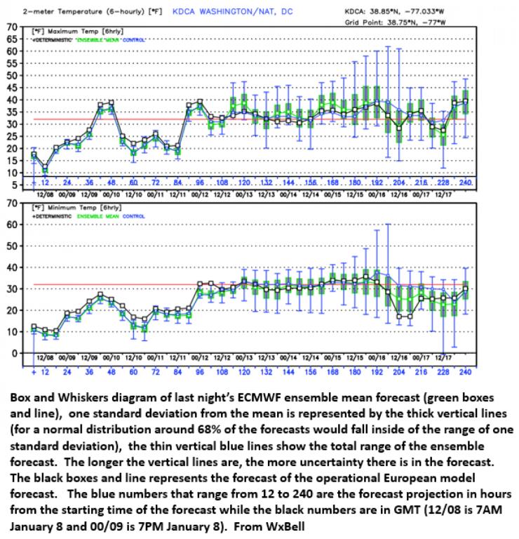
A look at the forecasts from last night’s European ensembles illustrates how much uncertainty is present (see below). The temperatures being forecast by the European operational model (black line) and ensemble mean (green line) for Reagan National Airport is shown below.
Through the entire 10 days, neither the ensemble mean or operational model predicts the maximum temperature to rise out of the 30s (top panel). However, they are also predicting that the minimum temperatures in DC will hover right near freezing during the period when our precipitation threat is highest.
The ensembles also suggest that the uncertainty in the temperature forecasts increases during that same period. Notice how the vertical boxes start getting taller by around 120 hours into the future. The length of those lines is a measure of the uncertainty of the forecasts with the vertical blue lines representing the spread of the ensemble member temperature forecasts.
Right around time that our precipitation threat grows on Monday, the uncertainty in how cold the temperatures will stay also grows. The spread is greatest right at the time that last night’s operational European model was predicting a coastal low might develop along the east coast. Through this entire period, some ensemble member keep it cold enough for wintry weather while others increase the temperature enough to keep any precipitation as rain. The possibility of cold air damming keeping surface temperatures colder than forecast is also a worry.
How confident are you in it being dry through the weekend and that next week will again turn stormy?
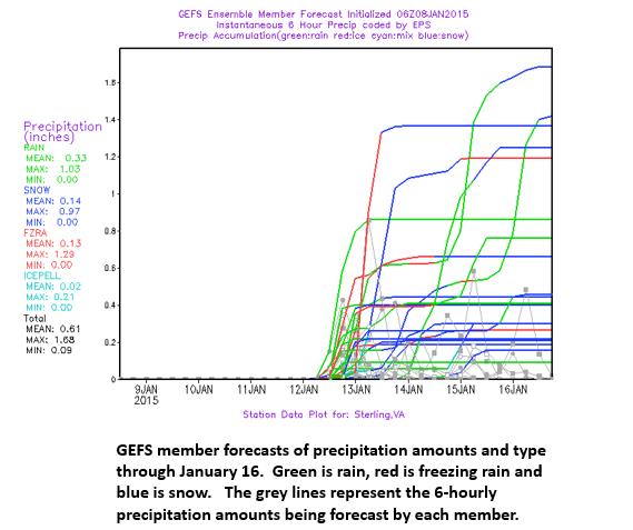
The GEFS plume diagram (see below) offers the forecasts for Sterling, Va., from the various ensemble members for the period through Jan. 17. Each line represents a different model forecast from the same model, but slightly different starting conditions.
The members are in accord that dry weather will hold on through the weekend but then the members start ramping up our precipitation chances. Most favor precipitation arriving in the area Monday and/or Tuesday but they differ on what type of precipitation.
More model runs favor rain (green) than freezing rain (red), but with their cruder vertical resolution than the operational models, they may have a tougher time handling damming than the higher resolution models. Despite that possible limitation, some members forecast freezing rain, and some offer snow during the week.
The take away is that the weather forecasts from Monday through Thursday should be monitored closely as there will be precipitation chances in a pattern that might produce enough damming to provide cold enough temperatures to support some type of winter weather.
Toward the end of your outlooks, you haven’t been that great. Why do you think we might warm up by the Martin Luther King, Jr. holiday?
Last night’s 5-day mean GEFS and ECMWF 500 mb height and anomaly forecasts for the period ending at 7 a.m. on Jan. 22 were in pretty good agreement about the basic pattern and what it might portend in terms of temperatures across the country (see below).
Both showed a strong positive height anomaly over the east with a hint of west southwesterly flow aloft. Note the orientation of the thin black lines. Our air at upper levels is coming from Texas. The negative height anomaly that develops over the west suggests that systems will again start wetting up California and that lows will probably reform to the lee of the Rocky Mountains and then will track northeastward towards the Ohio Valley or even Great Lakes putting us on the warm side of the low. Also, the onslaught of Pacific systems will lead to warmer than normal weather across much of the eastern two thirds of the country.
Left: 5-day European model 500 mb heights (black lines) and anomaly (colors) forecast for the period ending at 7 a.m. on Jan. 22. Right: Temperature departure from normal forecast for the 10 closest 500 mb patterns based on the European ensemble mean forecast compared to NCEP reanalysis. (weatherbell.com and stormvistawxmodels.com)
What’s the bottom line?
Cold through the weekend and then ugh, the picture gets muddled. Precipitation looks like a good bet but pinpointing the exact timing of systems and whether they will bring rain, snow or a mix is more problematical. Moderation of the temperatures is expected by MLK day but there is just enough a west northwesterly component over central Canada to make it tough to know how much.
Courtesy: Wash Post – Capital Weather Gang


