


January 26, 2014
The next blast of brutal cold will grip most of the eastern two-thirds of the United States in the upcoming days and could yield the lowest temperatures so far this winter in many communities.
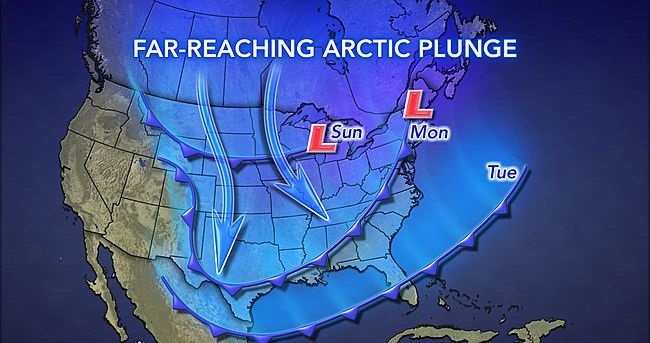
While harsh cold is returning to the Midwest and Northeast this weekend, it will pale in comparison to what will follow for Monday through Wednesday.
January 26, 2014
The next blast of brutal cold will grip most of the eastern two-thirds of the United States in the upcoming days and could yield the lowest temperatures so far this winter in many communities.
While harsh cold is returning to the Midwest and Northeast this weekend, it will pale in comparison to what will follow for Monday through Wednesday.
The impending polar plunge will rival the frigid days from earlier this January for the coldest daytime highs and nighttime lows so far this winter. That is especially true away from the Gulf Coast.
The arctic air will first plunge into the Upper Midwest, northern Plains and northern Rockies on Sunday then continue pressing to the south and east through Tuesday.
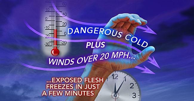
The magnitude of this cold blast will be enough to produce a far-reaching threat of frostbite, hypothermia, frozen pipes and water main breaks.
Care should also be taken to ensure that livestock and other animals housed outdoors have adequate shelter.
Especially across the Midwest and Northeast, officials may decide to cancel or delay school due to the extreme cold. Some vehicles may struggle or fail to start for motorists.
While highs will be held to the 30s southward to the I-20 corridor, the Midwest and Northeast are bracing for the harshest conditions.
Minneapolis, Chicago and other communities in the Upper Midwest will endure two consecutive days of subzero highs Monday through Tuesday. Overnight lows will drop to 20 below zero or lower from North Dakota to the western suburbs of Chicago.
Grand Forks, N.D., will bottom out at around 30 below zero.
Across most of the Northeast, highs will be held to the single digits and teens Tuesday and Wednesday.
Biting winds will usher in the frigid air, creating dramatically colder AccuWeather.com RealFeel® temperatures. Where snow is covering the ground, the winds will worsen the situation for motorists by blowing and drifting the snow around.
Temperatures will be extremely dangerous across eastern North Dakota, Minnesota, Wisconsin and Upper Michigan Sunday night, ranging from 50 below zero to 60 below zero.
Frostbite can develop in a matter of minutes on exposed skin during such intense cold.
Along the leading edge of the invading cold will be an Alberta Clipper, set to spread a few inches of snow from the northern Plains to the Great Lakes and northern New England through Monday.
While Detroit already set a January snow record, the clipper may cause other Midwestern cities to follow suit. Once the cold takes up residence, the lake-effect snow machine will be cranked up across the Great Lakes.
Snow will also drop along the Front Range of the Rockies, including Denver, as the cold presses southward.
Meteorologists are also monitoring the possibility of the cold setting the stage for snow to develop not only along the Northeast's coast at midweek, but also across the South.
Courtesy: Accuweather


