


FEBRUARY 19, 2025
The last in a long train of storms will bring snow and ice to the Mid-Atlantic and Carolinas on Wednesday.
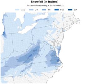
While Washington will be near the northern edge of the storm starting late in the morning — with a dusting to a half-inch of snow possible in the District and areas to the south by the evening — impacts will be moderate to major farther south. Interstate 95 in Virginia and North Carolina is set to be covered with snow and/or ice later Wednesday.
The wintry weather is moving eastward from the Plains and Midwest, where 8.8 inches of snow fell in Great Bend, Kansas; 11 inches in Oates, Missouri; and 7.5 inches in Grandview, Arkansas. Thundersnow was observed near Memphis on Tuesday night. But the storm will intensify as it reaches the Eastern Seaboard.
Freezing rain and sleet will affect eastern North Carolina and northern South Carolina, turning roads and sidewalks slick like skating rinks. A narrow swath of heavy snow is expected from northeastern North Carolina into southeastern Virginia and Maryland through Wednesday night. In Norfolk, it could be the biggest single-day snowfall in 15 years — since Dec. 26, 2010, when 13.6 inches fell.
From there, the storm will push offshore on Thursday while grazing Cape Cod and Nantucket, Massachusetts, with light snow.
Moderate to major winter storm impacts are expected in Virginia, Maryland and North Carolina on Wednesday. – Ben Noll/Data source: NOAA
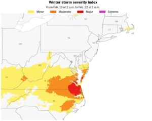
Where the worst weather will be on Wednesday
The worst of Wednesday’s weather will be found from central Virginia and southern Maryland through North Carolina, where snow, sleet and freezing rain will fall.
Snow, sleet and freezing rain will track from the Appalachians to the Mid-Atlantic on Wednesday. – Ben Noll/Data source: NOAA
Here’s a forecast for several cities in the storm’s track:
Ocean City, Maryland: Snow will develop in far southern Maryland in places including Ocean City, Pocomoke City and Salisbury during the late morning or early afternoon on Wednesday. With temperatures in the 20s, snow will have no trouble sticking as it turns steadier from the midafternoon through the evening. Snow will accumulate 2 to 4 inches by Thursday morning.
Richmond: Richmond-area schoolchildren will have a snow day on Wednesday as the storm moves in during the morning. Snow will be steadiest during the afternoon and continue through the evening before it ends. Snowfall of 2 to 4 inches is expected, with higher totals south of the Virginia capital.
Virginia Beach: Snow will probably develop during the late morning on Wednesday in southeastern Virginia, where it could turn out to be the biggest single-day snowfall in more than 15 years. Snow will become moderate to heavy during Wednesday afternoon and evening, with whiteout conditions possible at times. Travel will be dangerous through the night, with roads obscured by high snow drifts. By Thursday morning, the region could be digging out from 8 to 12 inches of snow. In Norfolk, snowfall has exceeded 6 inches on just three days in the last 35 years.
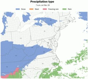
Raleigh, North Carolina: Wake County, home to Raleigh, will be at the crossroads of a variety of precipitation types starting late Wednesday morning. It looks like the snow and ice line — where precipitation could fall in either variation — could cross right through the county. Whether snow, sleet or freezing rain dominates, one thing is for certain: It’s going to be messy on the roads. By the time the storm ends early Thursday, it’s likely there will be 1 to 3 inches of snow and sleet and a glaze of ice. More significant icing will occur to the south and east of town, toward Fayetteville, Goldsboro and Greenville, with heavier snow to the northeast.
The storm will graze coastal New England on Thursday, potentially bringing a light snow accumulation to Cape Cod and Nantucket, Massachusetts.
The snow season so far
Around 66 percent of the United States has experienced below-average snowfall so far this season. The other 34 percent of the country has experienced above-average snowfall, excluding areas that don’t typically receive snow.
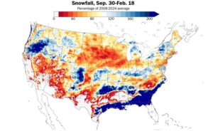
Snowfall has been below average across 66 percent of the United States so far this season. – Ben Noll/Data source: NOAA
When this week’s snow gets factored in, some of the orange and red areas on the map above may change to blue. Despite a high frequency of storms during February, it hasn’t been the snowiest winter in most places in terms of totals.
Areas around the Great Lakes have been unusually snowy so far this season, with a pattern of frigid air flowing over relatively warm lakes conducive to heavy lake-effect snow. The town of Lowville, New York, in the Tug Hill Plateau, has received around 401 inches overall, making it the snowiest place east of the Rocky Mountains.
A record-breaking Gulf Coast snowstorm in January brought one of the biggest snowfalls on record to New Orleans and the Florida Panhandle and caused parts of Alaska to briefly be warmer than Louisiana.
On the flip side, snowfall has been below normal across many parts of the Northeast, Midwest, northern Plains and Southwest.
Winter isn’t over, and there’s still time for things to change, but the weather pattern is expected to soon turn milder.
A trend toward warmer temperatures
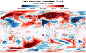
The most unusually cold air on the planet will be anchored over the United States on Wednesday and Thursday. – Ben Noll/Data source: ECMWF/ERA5
A lobe of the polar vortex is drifting southward, bringing some of the planet’s most unusually cold air to the United States on Wednesday and Thursday.
But by the weekend and early next week, the cold weather will be a distant memory as 50s, 60s and 70s return to many parts of the country.
Temperatures are currently forecast to reach at least the 50s in 42 of the 48 contiguous states next week. It will surge into the 60s, 70s and 80s across the south, feeling more like April than February.
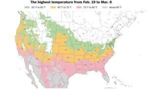
42 out of 48 states will reach at least the 50s next week across the contiguous United States. – Ben Noll/Data source: ECMWF/ERA5
The weather pattern also looks drier than normal, although warmer than average seas in the Gulf of Mexico may fuel more storms in early March.
Courtesy/Source: The Washington Post


