January 4, 2016
A glancing blow from the polar vortex will direct cold air southward and could raise the chance of snow in the central and eastern United States toward the middle of January.
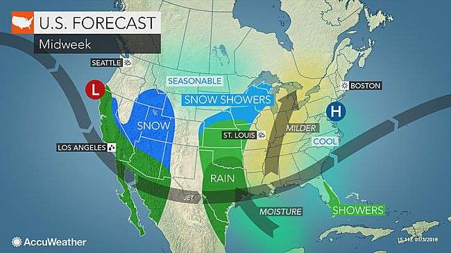
The pattern of cold air coming and going will be a theme through January.
January 4, 2016
A glancing blow from the polar vortex will direct cold air southward and could raise the chance of snow in the central and eastern United States toward the middle of January.

The pattern of cold air coming and going will be a theme through January.
According to AccuWeather Chief Meteorologist Elliot Abrams, "Arctic air will leave quickly, after giving the Great Lakes and Northeast a cold shock this week."
Temperatures will rebound to above-average levels in much of the Midwest and Northeast during the latter part of this week and this coming weekend.
High temperatures will return to the 30s in Minneapolis, the 40s in Chicago, the 50s in Washington, D.C., and the 60s in Atlanta for multiple days. The warmup will be of short duration.
According to AccuWeather Chief Long Range Meteorologist Paul Pastelok, "A major and far-reaching blast of cold air will sweep in over much of the Central and Eastern states next week [Jan. 10-17]."
The polar vortex will shift southward toward the Hudson Bay in Canada for a several-day stint during the second full week of January.
While this arctic blast is not uncommon for January, it will deliver a cold shock following record warmth during December. The cold will also affect a large swath of the nation.
While the core of the cold air with the arctic outbreak early this week focused on the Northeast, the outbreak next week will first plunge across the Rockies and Plains, before turning eastward.
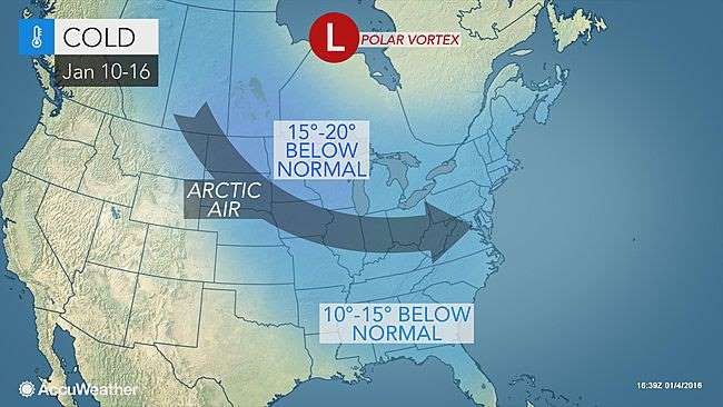
Even though the air will moderate as it moves along this path, there is still the likelihood of the lowest temperatures of the season so far from the northern Rockies and Plains to the Midwest, South and East by the middle of the month.
Temperatures will dip below average even for the middle of January.
During the second week of January, highs will be within a few degrees of zero F over the northern Plains and Upper Midwest. Lows will be well below zero in the region.
With the mid-month cold blast, multiple days with highs in the teens are likely in Chicago. High temperatures on one or more days in New York City could be held to the 20s. Temperatures could struggle to climb past the lower 40s as far south as Atlanta with hard freezes at night across the interior South. However, freezes are likely to stop short of the Florida Peninsula during the mid-month cold outbreak.
As the cold air first begins to push southward and eastward, a couple of storms will have the potential to bring a general swath of wintry precipitation from part of the interior South to the Northeast during the first half of next week.
How much snow falls and where will depend on the track and strength of the storms, Pastelok stated.
There is no guarantee that the pattern will bring accumulating snow in the swath from Washington, D.C., to New York City just yet.
In addition to a possible snowstorm, bands of heavy lake-effect snow will develop as the cold air streams across the Midwest during the middle days of the month. The pattern could unload a few feet of snow and produce local blizzard conditions, where lake-effect bands persist.
The staying power of the mid-month cold blast is uncertain at this time.
"Indications are the polar vortex will again retreat northward after several days," Pastelok said. "There is a significant chance that milder air from the Pacific will mix in from west to east beginning on or before the third week of January."
While the Pacific air would allow temperatures to trend to near or above average in many areas, the recovery would likely stop well short of record warmth.
"Because of a buildup of snow cover over eastern Canada and big storms moving offshore, cold air may continue to periodically invade part of the Northeast, especially New England, during the latter part of January," Pastelok said.
Courtesy: AccuWeather


