


NOVEMBER 30, 2020
Another cyclone, brewing in the southeast region of the Bay of Bengal, is headed towards southern Tamil Nadu and Sri Lanka coasts.
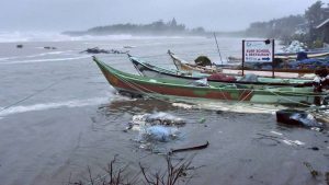
On November 25, severe cyclone Nivar had hit near Karaikal and brought along extremely heavy rain over Puducherry, Tamil Nadu and coastal Andhra Pradesh.
“We have noticed warmer sea surface temperatures recorded both in the Bay of Bengal and the Arabian Sea,” said Dr. D Sivanand Pai, head of Climate Research and Services at India Meteorological Department (IMD), Pune.
Such warming favour the development of cyclones. Meteorologists say that sea conditions during November remain most favourable for cyclone genesis in these two seas. Every year, about five cyclonic storms form in this region, four of which develop in the Bay of Bengal.
On Monday, the IMD set up a pre-cyclone watch. The Met office has said that a depression, which lay at about 1,120 kms east-southeast of Kanyakumari, is set to intensify within 12 hours and by Tuesday, it will develop as a cyclonic storm.
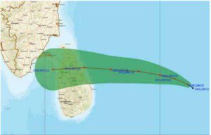
The projected trajectory of cyclone Burevi approaching Tamil Nadu. (Source: IMD)
“It will also intensify into a cyclonic storm and move west-northwestwards and cross Sri Lanka coast around December 2,” the special bulletin released by the IMD on Monday, stated. Once the system attains the strength of a cyclonic storm, it will be named ‘Burevi’.
Under the influence of this approaching cyclone, the weather bureau has issued a ‘red’ alert (take action) warning of very heavy to extremely heavy (more than 20cm) rain over southern districts of Tamil Nadu and Kerala on Wednesday. Rainfall will continue all through Tamil Nadu, Puducherry, Karaikal, Mahe, coastal Andhra Pradesh and Lakshadweep till December 5.
Squally winds with speeds ranging between 55 to 65 kms/hr gusting to 75 km/hr are very likely during the next two days. With sea conditions likely to remain extremely rough, fishermen have been warned against venturing into the sea till the end of this week.
Courtesy/Source: The Indian Express


